Revista de la Facultad de Ciencias
Agrarias. Universidad Nacional de Cuyo. Tomo 56(1). ISSN (en línea) 1853-8665.
Año 2024.
Original article
Rural
abandonment and its drivers in an irrigated area of Mendoza (Argentina)
Abandono
rural y sus causas en un área irrigada de Mendoza (Argentina)
Gabriela M.
Migale5,
María Agustina
Aranda2,
Andrea Magnano3†
1Instituto
Argentino de Nivología, Glaciología y Ciencias Ambientales (IANIGLA),
Universidad Nacional de Cuyo, Gobierno de Mendoza, CONICET. Av. Ruiz Leal s/n
(M5500).
2Universidad
Nacional de Cuyo. Facultad de Ciencias Exactas y Naturales. Padre Jorge
Contreras 1300 (M5502JMA) Mendoza. Argentina.
3Instituto
Argentino de Investigaciones de las Zonas Áridas (IADIZA), Universidad Nacional
de Cuyo, Gobierno de Mendoza, CONICET. Av. Ruiz Leal s/n (M5500).
4Universidad
Nacional de Cuyo. Facultad de Ciencias Agrarias. Almirante Brown 500 (M5528AHB)
Mendoza. Argentina.
5Universidad
de Buenos Aires. Facultad de Filosofía y Letras. Puan 480 (C1406CQJ). Ciudad
Autónoma de Buenos Aires. Argentina.
*bguidaj@mendoza-conicet.gob.ar
Abstract
Rural
abandonment is a global phenomenon promoted by biophysical, socio-economic, and
socio-productive causes, leading to the disappearance of traditional
agricultural practices and serious impacts on food security and local
livelihoods. This phenomenon is more complex in drylands since the lost of
productive land is unlikely to be recovered due to the limited availability of
water resources. This study aimed to identify abandoned agricultural lands in a
sector located east of the northern oasis of Mendoza (Argentina) and determine
the main driving forces leading this process. The interdisciplinary perspective
employed included the Normalized Difference Vegetation Index (NDVI) difference
technique implemented on Landsat images, the boosted regression trees analysis
of spatially explicit drivers, and a digital survey providing perception
assessments from local producers and their technical advisors. Abandoned
agricultural land has increased by 92% between 2002 and 2020, being
accessibility, crop type, vulnerable living conditions of the local population,
availability of irrigation water and labor, and the lack of profitability, the
main drivers identified by both sources of information (spatial model and social
perception). The proposed approach contributes to monitore productive resources
and land-use planning with a holistic and long-term vision.
Keywords: agricultural
land abandonment, NDVI difference technique, spatial modeling, social actors’
perception
Resumen
El abandono
rural es un fenómeno global promovido por causas biofísicas, socioeconómicas y
socioproductivas, que conduce a la desaparición de prácticas agrícolas
tradicionales y tiene graves impactos en la seguridad alimentaria y los medios
de vida locales. Este fenómeno es más complejo en las tierras secas, ya que es
poco probable que se recuperen las tierras productivas perdidas debido a la
disponibilidad limitada de recursos hídricos. Los objetivos de este estudio son
identificar tierras agrícolas abandonadas en un sector del este del oasis norte
de Mendoza (Argentina) y determinar las principales causas que conducen este
proceso. Se empleó una perspectiva interdisciplinaria, que incluye la
implementación de la técnica de diferencia del Índice de Vegetación de
Diferencia Normalizada (NDVI) a partir de imágenes Landsat, el análisis de boosted
regression trees para evaluar causas espacialmente explícitas y la
evaluación de la percepción de los productores locales y sus asesores técnicos
mediante una encuesta digital. Las tierras agrícolas abandonadas aumentaron un
92% entre 2002 y 2020 y los principales factores identificados por ambas
fuentes de información (modelo espacial y percepción social) fueron la
accesibilidad, el tipo de cultivo, las condiciones de vida vulnerables de la
población local, la disponibilidad de agua de riego, la disponibilidad de mano
de obra y la falta de rentabilidad. El enfoque propuesto busca contribuir al
monitoreo de los recursos productivos y a un ordenamiento territorial con una
visión holística y de largo plazo.
Palabras clave: abandono de
tierra agrícola, técnica de diferencia del NDVI, modelado espacial, percepción
de los actores sociales
Originales: Recepción: 26/09/2023 - Aceptación: 09/05/2024
Introduction
Rural
abandonment is a global phenomenon detected in diverse regions, such as Europe,
the United States, Asia, and Latin America (40). In general
terms, rural abandonment is mainly promoted by three types of causes: biophysical
(including factors such as elevation and slope, soil, or climate),
socio-economic (including market incentives, migration processes, inefficient
technology, land tenure, accessibility or characteristics of the producers)
and, thirdly, socio-productive (associated with inadequate agricultural
management leading to land degradation, overexploitation or loss of
productivity) (35). Abandonment
of productive land generally occurs in marginal agricultural areas and is
associated with low levels of profitability (3, 40). This affects
crop productivity even more and undermines investment, technological
advancement, and the achievement of acceptable economic returns deepening the
abandonment processes (37). Some authors
see this change in agricultural land use as an opportunity for the restoration
of ecosystem services and the recovery of biodiversity (19,
40),
depending on the level of degradation. However, the social consequences of
rural abandonment are extremely negative and include the disappearance of
traditional practices, seriously impacting food security and local livelihoods
(9, 12).
According to the
UNCCD
(2014),
52% of the world’s agricultural land is moderately or severely affected by land
degradation. Based on current consumption trends, it is estimated that
agricultural production will need to increase by 70% globally, and 100% in
developing countries, to meet population demands in 2050. Paradoxically, in
Latin America, 50% of agricultural land could be affected by desertification by
the same year (42). In this context and especially in drylands, inadequate
management of productive resources puts the producers’ subsistence and
livelihoods at risk. Drylands account for 47% of the earth’s land surface,
covering hyper-arid, arid, semi-arid, and dry sub-humid climate regions where
2.6 billion people live (23). In Argentina,
63% of the national territory constitutes drylands (43). In these
regions, where different irrigation systems transform arid ecosystems into
cultivable irrigated areas known as “oases”, water limits agricultural
production. This limitation further complicates the phenomenon of rural
abandonment. In arid to semi-arid Mendoza (Argentina) with 250 mm average
rainfall, irrigation depends on water from snowmelt in the Andes Mountains,
which feeds surface and underground water sources. Thus, after years of gaining
desert land through costly installations of irrigation systems, productive land
is lost with low replacement prospects.
In this context,
information systems have become valuable tools for managing datasets and
identifying critical areas affected by land degradation processes (37). In
particular, rural abandonment involves complex dynamics that, as such, must be
addressed from an interdisciplinary perspective, including biophysical and
socio-economic aspects. Therefore, the construction of spatial models in
geographic information systems (GIS) and their statistical analysis makes it
possible to associate local data on the occurrence of rural abandonment with
variables that describe the biophysical environment and anthropogenic uses.
Moreover, each variable has a relative assigned weight reflecting its influence
on the process. This approach has allowed several case studies (12,
30, 33, 40).
Given this multicausal problem, producer perspectives are valuable assets for
understanding perceived constraints, threats, and opportunities (10,
13).
Some studies have explored their perceptions of abandonment and plausible
causes (4, 24, 31), while others
have integrated quantitative data derived from spatial analysis with
qualitative data derived from social studies to analyze landscape changes (14,
16, 32).
Sustainability demands combining knowledge from different sources to achieve
deeper understanding of any given problem.
Rural
abandonment has been identified as an environmental problem in the oases of
Mendoza but has not yet been thoroughly quantified (1). A previous
study identified land-use changes between 2003 and 2019 in a district of the
Guaymallén department located in the northern oases (15). Although the
authors did identify the category of abandoned land, the employed methodology
had limited scalability since it consisted of a visual interpretation of
high-definition satellite images available on Google Earth. Both the observer
training as well as image availability may hamper analysis extension to the
entire oases. Another recent study identified land use and land cover changes
between 1986 and 2018 at a larger scale, the Mendoza and Tunuyán River Basins (36). In this case,
the methodology enabled an extensive analysis but did not explicitly identify
the category of abandoned land. Regarding causes of productive land
abandonment, Guida-Johnson et al. (2020) investigated
the perception of local actors but did not intend to perform spatial modeling.
Our study complements previous work and deepens the level of analysis. Rural
abandonment is a complex process that can be addressed, quantified, and
expressed spatially through an appropriate methodology. In this sense,
detecting crop abandonment and investigating possible causes will significantly
contribute to understanding rural abandonment dynamics at a local scale. Our
objectives were: (1) to identify
abandoned land in an irrigated area in the north of Mendoza province between
2002 and 2020 and (2) to determine
the main biophysical, socio-economic, and socio-productive drivers considering
spatial modeling and social actors perception.
Materials
and methods
Study
area
The productive
activities in Mendoza province (Argentina) are concentrated in three oases:
north (irrigated by the Mendoza and lower Tunuyán rivers), center or Valle de
Uco (irrigated by the upper Tunuyán river), and south (irrigated by the
Diamante and Atuel rivers). In particular, the northern oasis can be divided
into two zones with distinctive characteristics: east and center. The study
area was the department of General San Martín (figure 1), good
representative of the process of rural abandonment in eastern Mendoza.
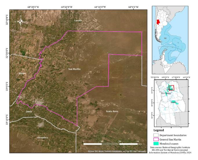
Figure 1. Location
of the study area.
Figura 1. Localización
del área de estudio.
Located in the
Mendoza plain, the department has an area of 1,507 km2, with its
capital city located 43 km from the provincial capital. San Martín is
characterized by a great diversity of soils and subsoil water availability,
which makes it suitable for crop development. The predominant natural
vegetation is xeric, psammophilous, or halophilous shrub steppe, scrubland, and
some small relicts of forest (5, 44). Land
degradation processes affect the entire area and accelerate the natural
phenomena of water and wind erosion (2). According to
the latest census (18), the
department has almost 140,000 inhabitants and a population density of 92.8
inhabitants/km2, most of them concentrated in the capital city, and
the rest distributed in small or medium-sized towns surrounding the main city.
Approximately 60% of the population over 5 years of age attended some
educational establishment (18). Considering
population density, health and service infrastructure, and logistics, San
Martín is the main department of eastern Mendoza. However, inequalities between
urban and rural populations regarding access to social infrastructure (such as
drinking water, public transportation, sewage, natural gas, electricity, or
waste collection) are profound. Considered one of the main grape-growing areas
in the country, the main economic activity is viticulture, followed by olive
and fruit production, as well as horticulture. The main economic units are
associated industries and family businesses. Historically, urban expansion over
rural areas has been carried out in a chaotic or disorderly manner,
transforming lands with high agricultural potential and accentuating
territorial imbalances.
Detecting
rural abandonment
A land-use
land-cover (LULC) map was used as a reference and satellite images were
analyzed by the Normalized Difference Vegetation Index (NDVI) difference
technique to detect changes (22, 27, 41). The
production map of Mendoza province constituted our reference. The map, prepared
and provided by the Institute for Rural Development [Instituto de Desarrollo
Rural, IDR], was created by visual interpretation of high-resolution images
available on Google Earth. LULC categories were: abandoned land, non-productive
tree cover, fruit trees, vegetables, natural vegetation, olives, pastures,
other uses (including swimming pools, and campsites), urban, vines, and vines
with olives.
The NDVI
difference technique is one algebraic change detection technique, simple and
easy to implement and interpret (25). Considering
the reference map, the study period was defined between 2002 and 2020. This
study used two atmospherically corrected satellite images transformed to
surface reflectance: one from the Landsat 5 TM sensor obtained in 2002 and one
from Landsat 8 OLI obtained in 2020. A preliminary assessment of monthly NDVI
variation associated with different LULC categories allowed image date
selection. In December 2019, 200 field points were surveyed. The largest
differences between cultivated and abandoned land were recorded in February
when both selected satellite images were obtained. The NDVI was calculated for
each scene from the reflectance values in the near-infrared (NIR) and red (R)
regions, following Eq. (1).
The NDVI
difference was then calculated (ΔNDVI) (Eq. 2). In the
resulting image, pixels were divided into no-change pixels with values around
zero and change pixels with values sufficiently far from zero (positive and
negative) (29).
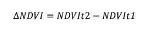
Where NDVIt2 is
calculated for the Landsat scene obtained in 2020 and NDVIt1 is calculated for
the Landsat scene obtained in 2002. One key issue is threshold definition, i.e.,
which value change is to be considered significant. In general, thresholds
associated with different numbers of standard deviations for NDVI values (σ)
are tested, visually choosing the one that best detects changes (27,
29, 41).
In this study, four thresholds were tested: 1σ, 1.5σ, 2σ, and the one
determined by the Jenks natural breaks classification method.
The changed
pixels interpretation was based on comparisons with the reference map
considering whether ΔNDVI was positive or negative. Detection of abandoned
rural land was performed as detailed in Table 1: no-change
pixels preserve their category, whereas change pixels are converted into
abandoned land (AL), cultivated land (CL) or not cultivated land (NCL).
Table
1. Criteria to detect abandoned
agricultural land based on NDVI difference technique and a reference map.
Tabla 1. Criterios
para detectar tierra agrícola abandonada basándose en la técnica de diferencia
del NDVI y un mapa de referencia.
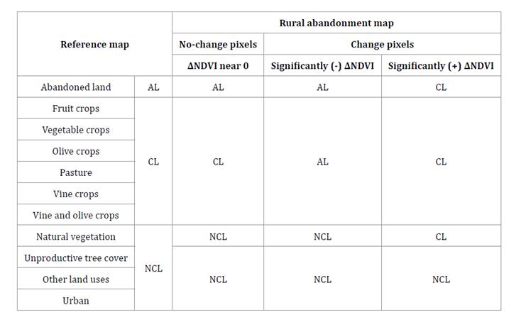
A rural
abandonment map was produced for each ΔNDVI threshold. Original LULC categories
from the reference map were regrouped into abandoned land, cultivated land
(including fruit trees, vegetables, olives, pastures, vines, and vines with
olives) and not cultivated land (non-productive tree cover, natural vegetation,
other uses, and urban).
The ΔNDVI
thresholds were assessed by validating the rural abandonment maps from ground
truth data. Three campaigns surveying GPS points in the study area were
conducted in December 2019, March 2021, and June 2021, collecting 537 sample
points. An error matrix was constructed for each map with these data, while
descriptive statistics were calculated. Total accuracy represents the
proportion of reference points correctly classified. Producer’s accuracy
indicates the probability of a reference point correctly classified, i.e. how
properly a particular area can be classified. Finaly, user’s accuracy estimates
the probability of a point on the map representing the class on the ground (6). A rural
abandonment map was selected based on statistics, and the area associated with
each category was calculated.
Identifying
rural abandonment drivers
Rural
abandonment drivers were identified and assessed using two sources of
information: a spatial model, and social actors perceptions. A GIS model
weighed the relative contribution of spatially explicit driving forces (12,
33).
To that end, 2000 points were randomly plotted on the selected rural
abandonment map to gather data and run a machine learning algorithm. For each
point, the response variable was presence or absence of rural abandonment.
Predictor variables were compiled from available geo-referenced secondary data of
three types, namely attributes of the biophysical environment, and
socio-economic and socio-productive aspects. The former included: (1) elevation
obtained from Shuttle Radar Topography Mission (SRTM) data (20); (2) aridity
index values, freely available from the Territorial Environmental Information
System of Mendoza [Sistema de Información Ambiental Territorial de Mendoza] (38); and (3)
frequency of storm damage events recorded during 2002-2017, available at the
Directorate of Agriculture and Climatic Contingencies of Mendoza website
[Dirección de Agricultura y Contingencias Climáticas de Mendoza] (7). The
socio-economic and socio-productive aspects included: (4) the original type of
crop obtained from the productive map of Mendoza provided by the Institute for
Rural Development; (5) population density, that is the number of inhabitants
registered by census unit, (6) the percentage of households with unsatisfied basic
needs (UBN), including overcrowded homes, precarious housing, poor sanitary
conditions, non schooled children or household head without complete schooling,
and (7) percentage of the working-age population who only reached primary
education level (i.e. those not meeting certain minimum conditions -
secondary education – in order to access formal employment), with data obtained
from the National Census of Population, Households and Dwellings 2010 [Censo
Nacional de Población, Hogares y Viviendas 2010] (17); (8) the
Euclidean distance to national and provincial roads available in the
Territorial Environmental Information System of Mendoza (39); (9) the
Euclidean distance to irrigation network and (10) to groundwater extraction
wells and (11) the density of canals and (12) wells, with data provided by the
General Department of Irrigation of Mendoza [Departamento General de Irrigación
(DGI)]. The values of all the predictor variables were recorded at each random
point.
The data were
analyzed by boosted regression trees (BRT) (30, 40) through R
software (34) using the
dismo package version 1.3-5. This approach uses boosting to combine large
numbers of relatively simple tree models to optimize predictive performance and
identify relevant variables, explaining an observed pattern (11). Model
parametrization was performed with tree complexity, which controls the number
of fitted interactions; the learning rate, which determines tree contribution
to the model; and the bag fraction, which defines the proportion of data
selected at each step (11). For this,
different combinations of tree complexity (1 to 9), learning rate (0.01, 0.005,
0.001, and 0.0005), and bag fraction (0.5 and 0.75) were tested (21,
28).
Model selecting criteria intended to maximize the explained deviance, i.e. variability
explained by the model, and minimized the difference between the training data
AUC score and the cross-validated AUC score, to reduce overfitting (8,
11).
Variables with relative influence under the expected by chance (100 divided by
the number of explanatory variables) were considered non-relevant for
interpretation (30). Considering
the 12 variables tested, in this case, the relative influence threshold was
8.33%.
Regarding social
perception, questions addressed abandonment causes and the areas and years in
which the phenomenon was evident in the department of San Martín. Focus was
placed on producers and their technical advisors. For this purpose, a pilot
study was conducted and a qualitative online survey was administered through a
Google Form. A total of 50 producers and/or advisors from San Martín were
contacted through different social networks. The survey consisted of five open
and closed questions on (1) major drivers of rural abandonment in the department
of San Martín (considering depth of the water table, crop type, population
density, access to road network, and water and labor availability), (2)
additional environmental or socio-economic and cultural factors impacting the
abandonment process; (3) localities with abandoned agricultural plots, (4)
localities in which this process occurred with greater intensity between 2002
and 2020, and (5) the time in which the process of abandonment was intensified
(dividing the period under analysis into three equal parts: 2002-2008,
2009-2014 or 2015-2020). The surveys were analyzed using descriptive statistics
and compared with the spatial analysis.
Results
Rural
abandonment maps derived from the four ΔNDVI thresholds found values of overall
accuracy between 0.70 and 0.77 (table 2).
Table
2. Total, producer’s, and user’s accuracy
associated with the four rural abandonment maps derived from assessed ΔNDVI
thresholds: Jenks Natural Breaks (NB), 1σ, 1.5σ y 2σ.
Tabla 2. Exactitud
total, del productor y del usuario asociadas a los cuatro mapas de abandono
rural generados a partir de los umbrales de ΔNDVI analizados: Quiebres
Naturales de Jenks (NB), 1σ, 1.5σ y 2σ.
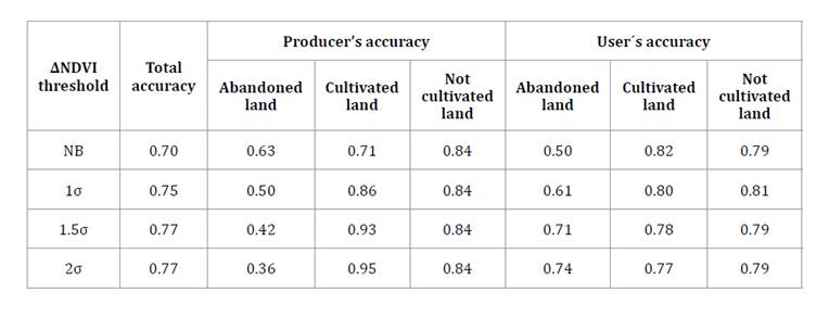
The differences
between these values lay in the accuracy with which abandoned and cultivated
land was identified. At one extreme, the map derived from the threshold given
by the Jenks Natural Breaks function correctly classified 63% of sample points
identified as abandoned land (producer’s accuracy 0.63), while it misclassified
29% of sample points identified as cultivated land (producer’s accuracy 0.71).
On the opposite, the map derived from the threshold defined as 2σ, correctly
classified 36% of sample points identified as abandoned land (producer’s
accuracy 0.36), with 95% of the sample points identified as cultivated land
correctly classified (producer’s accuracy 0.95). Considering this paper aims to
detect rural abandonment in the study area, the Jenks Natural Breaks function
was selected as ΔNDVI threshold.
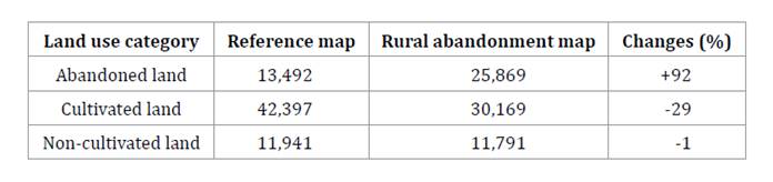
According to the
selected rural abandonment map, abandoned land increased by 92% during the
study period. This was calculated considering the 13,492 ha in the reference
map which was incremented to 25,869 ha in the 2020 rural abandonment map (table
3).
Table
3. Area (ha) for each land use category in
the reference map (Mendoza productive map elaborated by IDR) and in the rural
abandonment map (detected with NDVI difference technique). Variations are
indicated in (%).
Tabla 3. Área
(ha) para cada categoría de uso de suelo en el mapa de referencia (mapa
productivo de Mendoza elaborado por el IDR) y en el mapa de abandono rural (detectado
con la técnica de diferencia del NDVI). Se indican los cambios (%) entre ellos.
Four areas
concentrate abandoned land in north, central-west, central-east, and south San
Martín (figure
2).
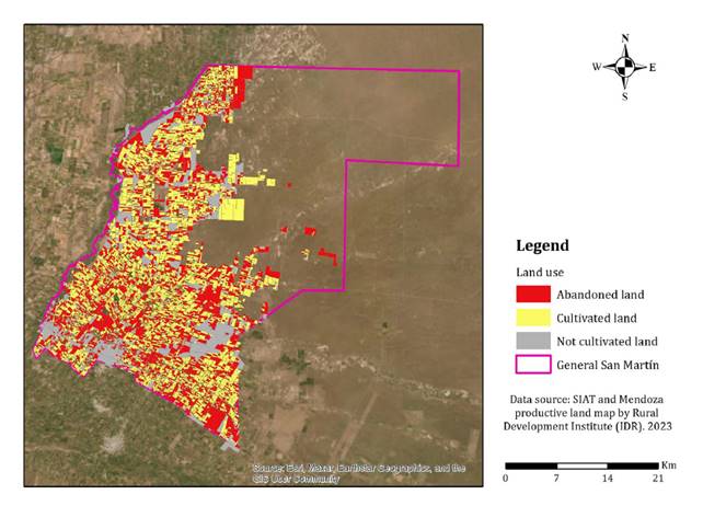
Figure 2. Rural
abandonment map for the study area in 2020.
Figura 2. Mapa
de abandono rural para el área de estudio en 2020.
The spatial
analysis indicated that the Euclidean distance to national and provincial
roads, crop type, percentage of households with unsatisfied basic needs (UBN),
distance to wells and irrigation canals, and density of canals and groundwater
extraction wells mostly explained the spatial distribution of abandoned land in
the study area (table 4).
Table
4. Relative influence of explanatory
variables for a BRT model developed with a tree complexity of 3, a learning
rate of 0.005, and a bag fraction of 0.5. Explained deviance was 24.62%
Tabla 4. Influencia
relativa de las variables explicativas para el modelo de BRT desarrollado con
complejidad de árbol de 3, tasa de aprendizaje de 0,005 y bag fraction de
0,5. La devianza explicada fue del 24,62%.
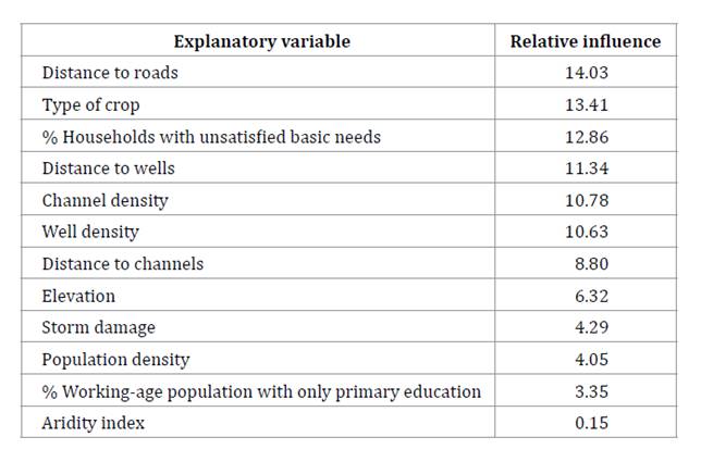
The model
explained 24.62% of the observed variability, probably due to the complexity of
the analyzed problem. Distance to roads indicates accessibility to agricultural
plots and accounts for management and harvesting difficulties. The crop would
be linked to production profitability and local, national, and international
market incentives and disincentives. The percentage of UBN households provides
idea of structural poverty conditions in which some producers or their
employees live (e.g., contractors who work and live on the farm and
receive a share of production profit), as well as households of local people
working in companies, especially during harvest time. Finally, the four
variables associated with irrigation canals and groundwater extraction wells
account for irrigation availability. It should be noted that, geographically,
San Martín largely covers the eastern boundary of the northern oasis of
Mendoza.
Twenty-seven out
of 50 producers and/or advisors completed the survey. Concerning the most
important drivers of land abandonment in San Martín, 85% of the respondents
pointed to irrigation availability, 81% to labor availability, and 67% to crop
type, in agreement with the spatial analysis. When asked what other biophysical
or socio-economic and cultural factors impact the abandonment process, 63% of
the respondents pointed to a lack of profitability. In addition, 15% indicated
difficulties associated with generational changes (in the words of the
interviewees “(...) aging of the vine-growers and lack of desire of the new
generations to continue with the activity”), 15% related to the regional
economy and another 15% associated with insecurity (robberies, vandalism, and
theft). When respondents were asked to indicate which districts in San Martín
currently had abandoned plots, 74% indicated Montecaseros, 56% El Divisadero
and 48% El Ramblón. Particularly, regarding the process between 2002 and 2020,
77% of respondents indicated Montecaseros, 58% El Ramblón and 46% El
Divisadero. Data from spatial analysis and surveys point to Montecaseros and El
Ramblón as two districts with intermediate evidence of rural abandonment (figure
3).
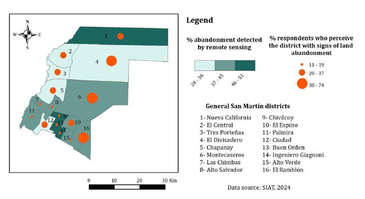
Figure 3. Location
of rural abandonment in the study area according to remote sensing and
respondents perception.
Figura 3. Localización
del abandono rural en el área de estudio según la teledetección y la percepción
de los encuestados.
Nueva California
district was identified by some respondents, but showed strong evidence of
rural abandonment in the spatial analysis. Conversely, El Divisadero was noted
by numerous respondents but showed less evidence of abandonment in the spatial
analysis. It is worth noting that southern districts, where a large amount of
abandoned land was detected according to the rural abandonment map, were
slightly mentioned by respondents. Finally, 65% of respondents indicated that
rural abandonment has intensified in the last period, 2015-2020.
Discussion
Rural
abandonment is a global phenomenon associated with biophysical, socio-economic,
and socio-productive causes (35, 40). In this
respect, our results are in line with other studies associating this phenomenon
with soil characteristics, topography and accessibility (12), the presence
of soils with agricultural potential and agricultural subsidies (9), topography,
accessibility, tractor and cropland density (30), crop yields
and accessibility (33), physical
environmental conditions, accessibility and global market pressures (3), equipment and
materials costs and property taxes (24) or lack of
state support, lack of occupation, demotivation of young people and lack of
educational centers (31). In the study
area, coincidences were found for both sources of information examined and also
with these previous studies. According to the spatial analysis, rural
abandonment would be associated with accessibility, type of crop, vulnerable
living conditions of the local population, and availability of irrigation
water. Whereas, the study of perception pointed to irrigation water and labor
availability, type of crop, and the lack of profitability as major causes. Crop
type is related to both profitability and agricultural management.
Regarding the
territorial dimension, the NDVI difference technique showed that abandonment had
increased in the analysed period at an alarming rate. All respondents
acknowledged rural abandonment in the study area, recently intensified and
associated with different districts in the department. The spatial pattern of
rural abandonment showed some divergences between satellite image analysis and
respondent perceptions. In some cases, both sources of information associated
the process of agricultural land abandonment with different districts. It is
worth noting that the sector where the greatest divergences were found (the
south) overlaps with a zone defined by intense urban and industrial land uses
in a matrix of cultivated areas. Two main, fast-growing cities in the
department are located there: Ciudad de San Martín and Palmira. Moreover, the
sector is crossed by National Route 7, one important commercial and tourist
highway in the country, connecting the Atlantic and the Pacific oceans and
integrating the Central Bioceanic Corridor. We could hypothesize that the
development of this area interferes with the perception of rural abandonment.
Although remote sensing analysis showed moderate to high levels of abandonment
in south San Martin, respondents associated the phenomenon with locations
farther away from these urban centers.
Remotely sensed
information provides up-to-date databases supporting land management. Regarding
rural abandonment, early detection of this type of change is particularly
relevant to prevent and mitigate land degradation, which becomes the most
efficient option. Thus, starting from an updated LULC map, detecting and
monitoring changes may simplify and speed up the analysis (26). The
methodology of LULC change detection used in this study resulted in a rapid
application and easy implementation and interpretation. Compared with a
previous study detecting abandoned land in a sector of the north oases (15), the
implemented methodology could enable a larger-scale monitoring of the process.
Therefore, the provided information could be useful for local authorities
(among other social actors) for detecting the most compromised districts,
speeding up the diagnosis, an invaluable phase of land use policy-making.
Rural
abandonment becomes more complex in drylands, naturally vulnerable to
degradation processes. In these regions, abandonment implies a loss of
productive land and the entire associated technological system that is unlikely
to be replaced due to the limited availability of water resources. Food
security and local livelihoods are seriously at risk (9,
12).
In this context, the complementation of quantitative data on landscape change
with the perception of the local community is highly relevant and leads to
understanding views, beliefs, and decisions of different social actors. This,
in turn, is key to formulating public policies addressing processes of
landscape change (14). On the other
hand, studying the perception of social actors promotes a better understanding
and interpretation of changes, enriches the explanation of driving factors, and
leads to a comprehension of the complexity of the socio-economic and cultural
context in which they occur (14, 16, 32). The
incorporation of local community knowledge in decision-making contributes to
strengthening alliances between the social actors involved, optimizing land-use
planning processes with a holistic and long-term vision in pursuit of
sustainable use of productive resources.
Conclusions
In the
department of San Martín, located east of the northern oasis of Mendoza
(Argentina), cropland abandonment increased by 92% between 2002 and 2020. As in
other places around the world, this phenomenon is multi-causal. Accessibility,
crop type, vulnerable living conditions of the local population, availability
of irrigation water and labor, and lack of profitability constitute main
drivers for land abandonment. Addressing this complex problem needs to
integrate different sources of information and skills to develop public
land-use planning policies that promote sustainable local development. The loss
of productive land in drylands threatens food security, determining the urgency
of preserving existing cultural and productive resources. The multidisciplinary
approach implemented in this study used different methodologies and sources of
information enabling a better understanding of the environmental problem.
Moreover, it allowed defining differences between the perception of local
social actors and the results derived from spatial analysis tools.
Understanding and managing territorial complexity from an interdisciplinary
perspective is essential to contributing knowledge to the local social reality.
Acknowledgement
This work was
supported by the Universidad Nacional de Cuyo under Grant SIIP 2019 Tipo 1
M079. The authors thank anonymous reviewers whose valuable comments and
suggestions helped improve the manuscript.
1. Abraham, E.
M. 2002. Lucha contra la desertificación en las Tierras Secas de Argentina; el
caso de Mendoza. In El agua en Iberoamérica; De la escasez a la
desertificación. ed A. Fernández Cirelli, E. M.
Abraham. p. 27-44. CYTED XVI Prólogo - Editores.
2. Abraham, E.;
Rubio, M. C.; Rubio, C.; Soria, D. 2017. Análisis del subsistema
físico-biológico. In Ordenar el territorio. Un desafío para Mendoza. p. 36-106.
EDIUNC. Colección Territorios.
3. Beilin, R.;
Lindborg, R.; Stenseke, M.; Pereira, H. M.; Llausàs, A.; Slätmo, E.; Cerqueira,
Y.; Navarro, L.; Rodrigues, P.; Reichelt, N.; Munro, N.; Queiroz, C. 2014.
Analysing how drivers of agricultural land abandonment affect biodiversity and
cultural landscapes using case studies from Scandinavia, Iberia and Oceania.
Land use policy. 36: 60-72.
4. Benjamin, K.;
Bouchard, A.; Domon, G. 2007. Abandoned farmlands as components of rural
landscapes: An analysis of perceptions and representations. Landsc Urban Plan.
83(4): 228-244.
5. Cabrera, Á.
L. 1971. Fitogeografía de la República Argentina. Boletín de la Sociedad
Argentina de Botánica. XIV(1-2): 1-42.
6. Congalton, R.
G. 1991. A review of assessing the accuracy of classifications of remotely
sensed data. Remote Sens Environ. 37(1): 35-46.
7. DACC
(Dirección de Agricultura y Contingencias Climáticas). Daños Zona Este.
www.contingencias.mendoza.gov.ar
8. Dedman, S.;
Officer, R.; Brophy, D.; Clarke, M.; Reid, D. G. 2017. Advanced spatial
modeling to inform management of data-poor juvenile and adult female rays.
Fishes. 2(3): 1-22.
9. Díaz, G. I.;
Nahuelhual, L.; Echeverría, C.; Marín S. 2011. Drivers of land abandonment in
Southern Chile and implications for landscape planning. Landsc Urban Plan.
99(3-4): 207-217.
10. Dougill, A.
J.; Twyman, C.; Thomas, D. S. G.; Sporton, D. 2002. Soil degradation assessment
in mixed farming systems of southern Africa: use of nutrient balance studies
for participatory degradation monitoring. Geogr J. 168(3): 195-210.
11. Elith, J.;
Leathwick, J. R.; Hastie, T. 2008. A working guide to boosted regression trees.
Journal of Animal Ecology. 77(4): 802-813.
12. Gellrich,
M.; Zimmermann, N. E. 2007. Investigating the regional-scale pattern of
agricultural land abandonment in the Swiss mountains: A spatial statistical
modelling approach. Landsc Urban Plan. 79(1): 65-76.
13. Giordano,
R.; Liersch, S. 2012. A fuzzy GIS-based system to integrate local and technical
knowledge in soil salinity monitoring. Environmental Modelling & Software.
36: 49-63.
14.
González-Puente, M.; Campos, M.; McCall, M. K.; Muñoz-Rojas, J. 2014. Places
beyond maps; integrating spatial map analysis and perception studies to unravel
landscape change in a Mediterranean mountain area (NE Spain). Applied
Geography. 52: 182-190.
15.
Guida-Johnson, B.; Sales, R. G.; Esteves, M. 2020. Presión de la expansión
urbana sobre territorios rurales de tierras secas irrigadas de Mendoza.
Reflexiones para el ordenamiento territorial. Revista de la Asociación
Argentina de Ecología de Paisajes. 9(1): 165-169.
16. Hearn, K.
P.; Alvarez‐Mozos, J. 2021. A diachronic analysis of a changing landscape on
the duero river borderlands of Spain and Portugal combining remote sensing and
ethnographic approaches. Sustainability. 13(24): 13962.
17. INDEC. 2013.
Censo Nacional de Población, Hogares y Viviendas 2010, procesado con
Redatam+SP. https://redatam.indec.gob.ar/argbin/RpWebEngine.exe
18. INDEC. 2022.
Censo Nacional de Población, Hogares y Viviendas 2022.
https://censo.gob.ar/index.php
19. Izquierdo,
A. E.; Grau, H, R. 2009. Agriculture adjustment, land-use transition and
protected areas in Northwestern Argentina. J Environ Manage. 90: 858-865.
20. Jarvis, A.;
Reuter, H. I.; Nelson, A.; Guevara, E. 2008. Hole-filled seamless SRTM data V4.
International Centre for Tropical Agriculture (CIAT). http://srtm.csi.cgiar.org
21. Jiang, L.;
Jiapaer, G.; Bao, A.; Li, Y.; Guo, H.; Zheng, G.; Chen, T.; De Maeyer, P. 2019.
Assessing land degradation and quantifying its drivers in the Amudarya River
delta. Ecol Indic. 107: 105595.
22. Karakani, E.
G.; Malekian, A.; Gholami, S.; Liu, J. 2021. Spatiotemporal monitoring and
change detection of vegetation cover for drought management in the Middle East.
Theor Appl Climatol. 144(1-2): 299-315.
23. Koutroulis,
A. G. 2019. Dryland changes under different levels of global warming. Science
of the Total Environment. 655: 482-511.
24. Kuntz, K.
A.; Beaudry, F.; Porter, K. L. 2018. Farmers’ perceptions of agricultural land
abandonment in rural western New York state. Land (Basel). 7(4): 1-11.
25. Lu, D.;
Mausel, P.; Brondízio, E.; Moran, E. 2004. Change detection techniques. Int J
Remote Sens. 25(12): 2365-2407.
26. Lunetta, R.
S.; Knight, J. F.; Ediriwickrema, J.; Lyon, J. G.; Worthy, L. D. 2006.
Land-cover change detection using multi-temporal MODIS NDVI data. Remote Sens
Environ. 105(2): 142-154.
27. Mancino, G.;
Nolè, A.; Ripullone, F.; Ferrara, A. 2014. Landsat TM imagery and NDVI
differencing to detect vegetation change: Assessing natural forest expansion in
Basilicata, southern Italy. IForest. 7(2): 75-84.
28. Meyer, M.
A.; Früh-Müller, A. 2020. Patterns and drivers of recent agricultural land-use
change in Southern Germany. Land use policy. 99: 104959.
29. Michener, W.
K. 1997. Quantitatively evaluating restoration experiments: research design,
statistical analysis, and data management considerations. Restor Ecol. 5(4):
324-337.
30. Müller, D.;
Leitão, P. J.; Sikor, T. 2013. Comparing the determinants of cropland
abandonment in Albania and Romania using boosted regression trees. Agric Syst.
117: 66-77.
31. Muñoz-Rios,
L. A.; Vargas-Villegas, J.; Suarez, A. 2020. Local perceptions about rural abandonment
drivers in the Colombian coffee region: Insights from the city of Manizales.
Land use policy. 91: 104361.
32.
Pătru-Stupariu, I.; Tudor, C. A.; Stupariu, M. S.; Buttler, A.; Peringer, A.
2016. Landscape persistence and stakeholder perspectives: The case of Romania’s
Carpathians. Applied Geography. 69: 87-98.
33. Prishchepov,
A. A.; Müller, D.; Dubinin, M.; Baumann, M.; Radeloff, V. C. 2013. Determinants
of agricultural land abandonment in post-Soviet European Russia. Land use
policy. 30(1): 873-884.
34. R
Development Core Team. 2019. R: A language and environment for statistical
computing.
35. Rey Benayas,
J. M.; Martins, A.; Nicolau, J. M.; Schulz, J. J. 2007. Abandonment of
agricultural land: an overview of drivers and consequences. CAB Reviews:
Perspectives in Agriculture, Veterinary Science, Nutrition and Natural
Resources. 2(57): 1-14.
36. Rojas, F.;
Rubio, C.; Rizzo, M.; Bernabeu, M.; Akil, N.; Martín F. 2020. Land use and land
cover in irrigated drylands: A long-term analysis of changes in the Mendoza and
Tunuyán River basins, Argentina (1986-2018). Appl Spat Anal Policy. 13(4):
875-899.
37. Salvia, R.;
Quaranta, V.; Sateriano, A.; Quaranta, G. 2022. Land resource depletion,
regional disparities, and the claim for a renewed “sustainability thinking”
under early desertification conditions. Resources. 11(3): 28.
38. SIAT
(Sistema de Información Territorial y Ambiental). 2013. Índice de aridez.
www.siat.mendoza.gov.ar
39. SIAT
(Sistema de Información Territorial y Ambiental). 2014. Ejes de calles.
www.siat.mendoza.gov.ar
40. Smaliychuk,
A.; Müller, D.; Prishchepov, A. V.; Levers, C.; Kruhlov, I.; Kuemmerle, T.
2016. Recultivation of abandoned agricultural lands in Ukraine: Patterns and
drivers. Global Environmental Change. 38: 70-81.
41. Sohl, T. L.
1999. Change analysis in the United Arab Emirates: An investigation of
techniques. Photogramm Eng Remote Sensing. 65(4): 475-484.
42. UNCCD
(United Nations Convention to Combat Desertification). 2014. The land in
numbers. Livelihoods at a tipping point. 1-22.
https://www.unccd.int/sites/default/files/documents/Land_In_Numbers_web.pdf
43. Verón, S.
R.; Lizana, P. R.; Maggi, A. 2022. Cartografía de las tierras secas en
Argentina, índice de aridez en el periodo 1981-2020.
44. Vignoni, A.
P.; Peralta, I. E.; Abraham, E. M. 2023. Fragmented areas due to agricultural
activity: native vegetation dynamics at crop interface (Montecaseros, Mendoza,
Argentina). Revista de la Facultad de Ciencias Agrarias. Universidad Nacional
de Cuyo. Mendoza. Argentina. 55(2): 46-60. DOI:
https://doi.org/10.48162/rev.39.108.